Fülszöveg
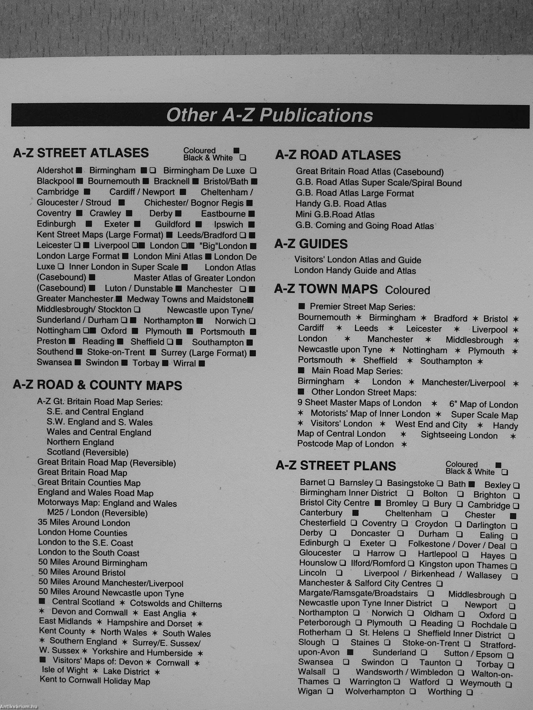
Other A-Z Publications
A-Z STREET ATLASES
Coloured ¦ Black White ?
Aldershot ¦ Birmingham ¦ ? Birmingham De Luxe ? Blackpool ¦ Bournemouth ¦ Bracknell ¦ Bristol/Bath ¦ Cambridge ¦ Cardiff/Newport ¦ Cheltenham/ Gloucester / SUoud ¦ Chichester/ Bognor Regis ¦ Coventry ¦ Crawley ¦ Derby« Eastbourne« Edinburgh « Exeter « Guildford « Ipswich « Kent Street l^aps (Large Format) « Leeds/Bradford ? « Leicester ? ¦ Liverpool ?« London ?« 'BigTondon « London Large Format« London Mini Atlas « London De Luxe ? Inner London in Super Scale « London Atlas (Casebound) « Master Atlas of Greater London
(Casebound)« Luton / Dunstable ¦ Manchester ?« Greater Manchester« Medway Towns and Maidstone« Middlesbrough/ Stockton ? Newcastle upon Tyne/ Sunderland/Durham? « Northampton« NonwichQ Nottingham ?« Oxford « Plymouth « Portsmouth « Preston « Reading « Sheffield ? « Southampton « Southend « Stoke-on-Trent « Surrey (Large Format)« Swansea « Swindon « Torbay « Wirral «
A-Z ROAD COUNTY MAPS
A-Z...
Tovább
Fülszöveg
Other A-Z Publications
A-Z STREET ATLASES
Coloured ¦ Black White ?
Aldershot ¦ Birmingham ¦ ? Birmingham De Luxe ? Blackpool ¦ Bournemouth ¦ Bracknell ¦ Bristol/Bath ¦ Cambridge ¦ Cardiff/Newport ¦ Cheltenham/ Gloucester / SUoud ¦ Chichester/ Bognor Regis ¦ Coventry ¦ Crawley ¦ Derby« Eastbourne« Edinburgh « Exeter « Guildford « Ipswich « Kent Street l^aps (Large Format) « Leeds/Bradford ? « Leicester ? ¦ Liverpool ?« London ?« 'BigTondon « London Large Format« London Mini Atlas « London De Luxe ? Inner London in Super Scale « London Atlas (Casebound) « Master Atlas of Greater London
(Casebound)« Luton / Dunstable ¦ Manchester ?« Greater Manchester« Medway Towns and Maidstone« Middlesbrough/ Stockton ? Newcastle upon Tyne/ Sunderland/Durham? « Northampton« NonwichQ Nottingham ?« Oxford « Plymouth « Portsmouth « Preston « Reading « Sheffield ? « Southampton « Southend « Stoke-on-Trent « Surrey (Large Format)« Swansea « Swindon « Torbay « Wirral «
A-Z ROAD COUNTY MAPS
A-Z Gt. Britain Road Map Series; S.E. and Central England S.W. England and S. Wales Wales and Central England Northern England Scotland (Reversible) Great Britain Road Map (Reversible) Great Britain Road Map Great Britain Counties Map England and Wales Road Map Motorways Map: England and Wales
M25 / London (Reversible) 35 Miles Around London London Home Counties London to the S.E. Coast London to the South Coast 50 Miles Around Birmingham 50 Miles Around Bristol 50 Miles Around Manchester/Liverpool 50 Miles Around Newcastle upon Tyne
¦ Central Scotland + Cotswolds and Chilterns
* Devon and Cornwall * East Anglla + East Midlands * Hampshire and Dorset ¦ Kent County * North Wales * South Wales
¦ Southern England ¦ Surrey/E. Sussex/ W. Sussex* Yori<shire and Humberside +
¦ Visitors' Maps of: Devon + Cornwall ¦ Isle of Wight + Lake District +
Kent to Cornwall Holiday Map
A-Z ROAD ATLASES
Great Britain Road Atlas (Casebound)
G.B. Road Atlas Super Scale/Spiral Bound
G.B. Road Atlas Large Format
Handy G.B. Road Atlas
Mini G.B.Road Atlas
G.B. Coming and Going Road Atlas
A-Z GUIDES
Visitors' London Atlas and Guide London Handy Guide and Atlas
A-Z TOWN MAPS Coloured
« Premier Street Map Series:
Bournemouth + Birmingham ¦ Bradford ¦ Bristol ¦ Cardiff ¦ Leeds ¦ Leicester * Liverpool + London * Manchester * Middlesbrough * Newcastle upon Tyne * Nottingham ¦ Plymouth * Portsmouth * Sheffield + Southampton * « Main Road Map Series:
Birmingham ¦ London * Manchester/Liverpool + « other London Street Maps:
9 Sheet Master Maps of London * 6" Map of London * Motorists' Map of Inner London ¦ Super Scale Map + Visitors' London * West End and City * Handy Map of Central London + Sightseeing London ¦ Postcode Map of London +
A-Z STREET PLANS
Coloured ¦ Blacks White ?
Barnet ? Barnsley ? Basingstoke ? Bath « Bexley ? Birmingham Inner District ? Bolton ? Brighton ? Bristol City Centre « Bromley ? Bury ? Cambridge ? Canterbury « Cheltenham ? Chester « Chesterfield ? Coventry ? Croydon ? Dariington ? Derby ? Doncaster ? Durham ? Ealing ? Edinburgh ? Exeter ? Folkestone / Dover / Deal ? Gloucester ? Harrow ? Hartlepool ? Hayes ? Hounslow ? llford/Romford ? Kingston upon Thames ? Lincoln ? Liverpool / Birkenhead / Wallasey ? Manchester & Salford City Centres ? Margate/Ramsgate/Broadstairs ? Middlesbrough a Newcastle upon Tyne Inner District ? Newport ? Northampton ? Nonivich ? Oldham ? Oxford ? Peterborough ? Plymouth ? Reading ? Rochdale ? Rotherham ? St. Helens ? Sheffield Inner District ? Slough ? Staines ? Stoke-on-Trent ? Stratford-upon-Avon « Sunderland ? Sutton / Epsom ? Swansea ? Swindon ? Taunton ? Torbay ? Walsall ? Wandsworth / Wimbledon ? Walton-on-Thames ? Warrington ? Watford ? Weymouth ? Wigan ? Wolverhampton ? Worthing ?
Vissza